


Miyakojima Tourist Guide

-
Ikema Bridge
-
Cape Nishi-Henna
-
sun pillar
-
Ogami Island
B.
-
伊良部大橋
-
通り池
-
17END
C
-
IMGA Marine Garden
-
Miyakojima City Underground Dam Museum
D.
-
Cape Higashi-Henna
-
tsunami rock
-
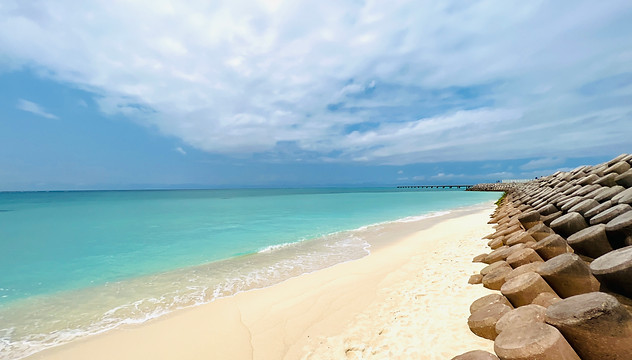
Aragusuku Beach
E
-
来間島

Ikema Island
Ikema Island isMiyakojimalocated 1.5 km northwest ofOkinawa PrefectureMiyakojima CityBelongs to Hirara Pondislandis. On the north side of Ikema Island,scenic spotas well asnatural monumentJapan's largest table-shaped pool called Yabiji, which is designated ascoral reefCrowds are spreading.

Ikema Bridge
Ikema Ohashi Bridge is a 1,425m long bridge located in the northwest of Miyakojima City, Okinawa Prefecture, connecting Miyakojima and Ikemajima, and opened on February 14, 1992. Until Kurima Ohashi Bridge opened in March 1995, it was the longest bridge in Okinawa Prefecture.

Cape Nishihennazaki
Cape Nishi-HennazakiMiyakojimaat the western end ofEast China Seafacingcape. From the middle of the cape to the tip,Wind-power generationin order towindmillwere established, but2002Typhoon No. 16 collapsed one[2], and the remaining four2003ofTyphoon 14collapsed by Since then, it has not been restored for a long time, but in June 2008, two units were restored and started operation.

Primal rhythm:
sun pillar
七光湾に2点組の作品《プライマルリズム》を設置するという、前衛芸術家、森万里子氏による自然と人類を結びつける壮大なアートプロジェクトの1つとして設置された作品です。アクリル製で高さ5.2m、重量は5tで2011年7月に完成。アクリルの多層構造で太陽光が当たると色が変わるそうです。不思議で神秘的な光景が見れます。

大神島
Ogami Island isMiyako Islandsofislandis one of It has an area of 0.24 km2 and a population of 22.
The entire island is called a “sanctuary (power spot),” and the locals have long worshiped it as an “island where the gods live.” You can cross it by boat and enjoy snorkeling.


伊良部大橋
Total length 3,540metersAt (m), it is the longest toll-free bridge in Japan. The bridge that crosses the unbelievably blue sea is one of Miyakojima's most Instagrammable spots.

Tori Pond
Tori Pond, located on the hill along the coast on the west side of Shimojishima Airport, is a general term for two ponds side by side. The pond on the inland side is about 55m in diameter and about 40m deep, and the pond on the sea side is about 75m in diameter and about 50m deep. The two ponds are actually connected underground, which is the origin of the name "Tooriike".

17END
The tip of Shimojishima Airport is the coast, and it is called 17END (One Seven End) because planes land at a direction of 170 degrees, assuming true north is 0 degrees. Located at the tip of a runway approximately 3,000 meters long, it is also known as the ``sacred place for aviation enthusiasts.'' It is also called a ``phantom beach'' because the white sand beach only appears at low tide.

Imgya Marine Garden
Imugya Marine Garden is a seaside park located in Miyakojima City. It is affectionately called "Ingya" by the locals. The word ``ingya'' means surrounded spring water. As the name suggests, the topography resembles a natural enclosed cove.

Miyakojima City Subsurface Dam Museum
On Miyakojima, the world's first underground dam prototype was experimentally developed and is now preserved as a memorial park. (Minafuku underground dam) Two units are in operation and one new unit is under construction. This is a place where you can learn everything about Miyakojima's underground dams.


東平安名崎
Higashihennazaki is a tourist destination representing Miyako that has been designated as a national scenic spot. It is a long and narrow slope that extends straight through the sea, and because of its great view, it is also a famous spot for seeing the first sunrise of the year, and has been selected as one of Japan's top 100 city parks.

tsunami rock
There are many huge rocks about 6 to 8 meters wide within the reef of Cape Higashihenna. These rocks are said to have been washed up by the ``Meiwa Tsunami'' that occurred in 1771 (the 8th year of Meiwa, mid-Edo period), and are therefore called ``Tsunami Rocks.''

Shinjyou Coast
Aragusuku Kaigan is a shallow coast, and even shallow watertropical fishbecause you can seesnorkelingSuitable for
There is a high chance of encountering sea turtles.

Ikema Bridge
Ikema Ohashi Bridge is a 1,425m long bridge located in the northwest of Miyakojima City, Okinawa Prefecture, connecting Miyakojima and Ikemajima, and opened on February 14, 1992. Until Kurima Ohashi Bridge opened in March 1995, it was the longest bridge in Okinawa Prefecture.
プライマルリズム:
サンピラー
The two-piece work ``Primalism'' was installed in Shichiko Bay as part of a grand art project by avant-garde artist Mariko Mori that connects nature and humanity. Made of acrylic, it is 5.2m high and weighs 5t, and was completed in July 2011. The multi-layered acrylic structure changes color when exposed to sunlight. You can see a mysterious and mysterious sight.
Okami Island
Ogamijima is one of the islands in the Miyako Islands. The area is 0.24km2 and the population is 22 people.
The entire island is said to be a "sanctuary (power spot)" and has been revered locally as the "island where the gods live" since ancient times. You can cross by boat and enjoy snorkeling.

Kurima Bridge
A bridge with a total length of 1,690m. Opened on March 13, 1995.
It was originally constructed as part of a farm road, and at the time of its opening, it was the longest farm road bridge in Japan and is currently the second longest in the Miyako Islands after Irabu Ohashi.

Ryugujo Observation Deck
A three-story observation deck modeled after Ryugu Castle on Kurima Island. You can see the Yonaha Maehama beach in front of you.
By the way, in the story of Urashima Taro, which is passed down on Miyakojima, he rides a stingray to Ryugu Castle instead of a turtle.

ユニの浜
There is a ``phantom island'' on the south side of Irabu Ohashi Bridge that is only visible at low tide. That is "Uni-no-hama". "Uni-no-hama" is known as one of the most beautiful beaches on Miyakojima, and you can enjoy its highly transparent sea, white sand, the mysterious feeling of standing in the middle of the sea, and the spectacular 360° view of being surrounded by the sea. !
